Table of Contents
Spatial data is an essential factor for Geographical Information systems. Today, we will explore a location with proper data with the coordinates. By using coordinates, it is easy to compare or relate the objects of the earth’s surface. Doing analysis with this geographic location, we can drive solutions for the various problems with new advanced technologies which are commonly known as “Spatial Analysis”.
Data used in Spatial Analysis
To illustrate the real world, there are two types of data used in Spatial Analysis.
1. Vector data
It has vertices and paths that represent the Point, line or Polygon features. All the discrete features can be represented in the vector type. Information about each feature can be stored using XY Coordinates. Example, Road Network, Country boundaries, Restaurant Rest location, etc.,
2. Raster data
Raster data is a set of data, made up of grid cells that have unique value, arranged in row/column-wise. To represent the surface feature. It stores the information by a square on a cell basis. It includes all satellite images and aerial imagery. It includes two types of raster data,
- Discrete data
- Continuous data
An example of discrete data is the Building area. Continuous data has an example of Precipitation.
What is spatial analysis?
Spatial Analysis is the analysis of geographic locations using maths and statistics. It uses GIS technologies and methods to depict the real world such as predictions for climate, current trends, determinations of crisis, pandemics, variations in the data collected, decision making in complex situation be it business or Government, site analysis for finding the perfect locations, etc.,
It is a toolkit where you can access all your required geographical data which are fed as inputs based on the desired tasks. Advanced geoprocessing tools are used for effective analysis. The results will be shown as a map with charts or statistics.
Spatial analysis is used in various fields, here I have listed the major departments where spatial data and analysis are considered an essential part.
Site Suitability Analysis
Today, choosing the best location for constructions, real estate, houses, constructing hospitals, power plants, etc. Location-based intelligence gives a better result by integrating all data like soil data, traffic data, mobile data, etc.,
For instance one of the US-based e-commerce company wanted to expand into a European market, they would like to find additional distribution centers based on their current transaction data in Europe.
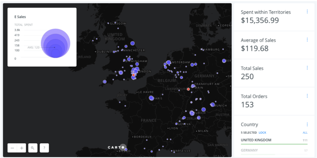
The results show that, based on their transaction from five top countries, two locations of distribution centers (Near Frankfurt and London). In addition to that, companies also will consider some factors in their account while making the decision before fixing the final destination.
You can also read: Geographical Information System (GIS) in Urban Planning
Water supply and Distribution
Improvising the existing water supply system and providing new facilities is possible with the field survey and questionnaire survey to analyze the demand for water in a particular zone. The data can be used to minimize the possibility of water scarcity where there is a high population or to decide whether its a low lying or a dry area.
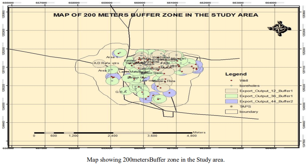
One of the Case studies was carried out to analyze the distribution of public potable water facilities in Misau Town, Bauchi State, Nigeria.
They have collected the data which are listed below,
- Detailed map of Misau town,
- Location of all water facilities from the state water board,
- Population data
- Field observation using GPS receivers
With the help of a buffer tool, you can create a buffer zone of 200m distance from each water point. It was seen from the map that points, located outside of the buffer zone which needs extra care to capture the scarcity by balancing the water access or to lay down new water facilities.
Agricultural and Food security
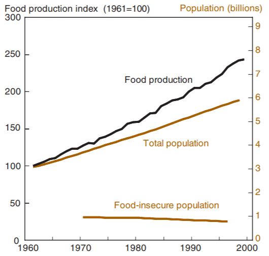
Based on the food and drought condition, we can judge the wealth of the country easily. Food insecurity mainly arises due to the population growth, Market fluctuations, extreme bad events like drought, water scarcity, etc., In developing countries, it is better to consider food security as a prime factor to achieve Millennium Development Goals (MDG). The below figure shows the World food production and population,
1960-2000.
Climate change is another factor that totally controls agriculture in terms such as insufficient rainfall, temperature variations, high evaporation rate results in low/high productivity. These can be related by regression analysis, correlation analysis, and trend analysis.
By predicting future events by doing overlay analysis/trend analysis using historical weather data, statistics of socio-economic and population data, we can mitigate the drought in advance, adopt the new crop varieties which can tolerate the new climate, and achieve food security.
Crime Analysis
The availability of the digital format of crime data with good quality and robustness of GIS Software expands the use of spatial analysis in Police departments to find where crime occurs, tracking down the criminal history, which is the most frequent crime occurring places, crime patterns.
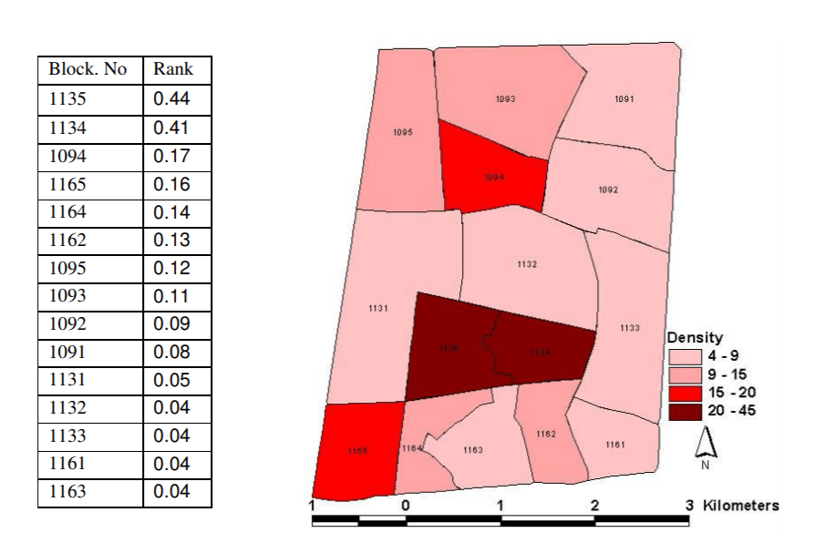
Crime mapping helps to visualize the spatial data into a map by hot spot analysis which shows where the high density of crime occurred and how it varies in high/low populated areas. Hot spot analysis helps the department to allot patrol on specific areas or deploy the officers in the worst situation and take prevention strategies by assigning weightage to each factor involving in the crime.
For example, here is an overall assessment of crime density for society is given below.
Related: 30 Best Satellite Maps To See Earth in New Ways
Final Thoughts
In fact, spatial analysis has become a part of a lifestyle. For instance, booking a taxi, tracking our order from the source point and moving one location to another, etc. With modern technologies like GIS, it became a vital part. The spatial analysis helps us find where and when the events occurred, how they relate to each other and used to measure the depth, heights, distances, etc, and also predict the events with a more detailed view.
In GIS, Spatial Analysis is the most useful tool to study spatial data by interpolating them together to bring the information that is important for decision making, visualizing the land use pattern by decade, futuristic study, creating new things like road networks, and buildings and their methods and technologies are most welcoming in action planning.
Like this post? Subscribe to the exclusive newsletter and stay updated on GIS development technologies every week.


