Table of Contents
Site Suitability Analysis is capable of finding the best location using multi-selection criteria. It is achieved via the modeling workflow. In the GIS world, the trending of the analysis was done via Webgis. By the integration of the site suitability analysis and the webgis trend, able to found out the best location for relocating the organization. The final output of the suitability analysis is in the map format. It gives the best location or area which is suitable for particular use in the form of a thematic map. It segregates areas based on the user-defined criteria.
I Would like to share my ideas to find the best site for the IT Sector using Site Suitability analysis in GIS.
I would like to share the real-world example for site suitability analysis to find the best location for the IT sector. It is done by two-phases.
-
- In Phase 1, find the locality of the company shifting. it is done using the visualization method in webgis.
- In Phase 2, analyze the suitable locality and find the exact best place for relocating the organization.it is achieved by some GIS analysis tools.
Use Case: Site Selection for IT Sector
Some common generalized criteria are discussed below while relocating an IT sector in the core city.
- Transportation Facilities for easy accessibility.
- The driving distance for employees.
- Cost of rent spending on office space.
- Basic Survival elements such as hospitals, restaurants, ATMs, etc.
- Spacing capability such as seating capacity, conference room, Cafeteria, Reception & washroom facilities.
- The infrastructure of the office location such as furnished, UPS, Availability of EB line, LAN & Extension of power cord facilities.
- Parking space facilities.
- Safety & security of the location.
Phase 1
Find the locality of the company shifting.
In this phase, able to analyze the suitable area to shift the organization using visualization techniques in webgis.
ALSO READ: How To Develop A Healthcare Mobile Application For Hospitals
Visualization method: it is achieved by the overlaying of prepared basic thematic layers in a single platform.
The Interactive Web Map
Here, transportation facilities like road networks and railway networks are represented using an open street map. But, it is in raster format. For easy interpretation, use the transportation facilities that are added as a vector format. It is used to give a clear idea about the transportation network. Driving distance is estimated using the road networks. The driving distance of the employees which they travel to reach the office. It is estimated using the isochrone method. It shows the driving distance of each employee (in meters/Kilometers). By using isochrone, one can able to estimate the driving cost too. Then, the important factor for choosing the area is the rent price of the location, where the average rent price for 5000 square feet is categorized into high, medium, and low. Also, it shows the number of employees in each locality. Then, the basic survival elements such as hotels, restaurants, hospitals, ATM, Bus stops, Railway stations, Metro are visualized as a point with different symbologies. Parking, Fuel stations, and Signals are represented as an automotive point layer. You can visualize the existing business using an open street map.
The parameters which we consider to choose the exact location such as the number of seating capacity, Electrical facilities, Parking, Water Facilities, the number of conference rooms, the number of the Reception areas, the number of Washrooms, and Security are visualized as suggested New location Sites.
Phase 2
Analyze the suitable locality and find the exact best place for relocating the organization.
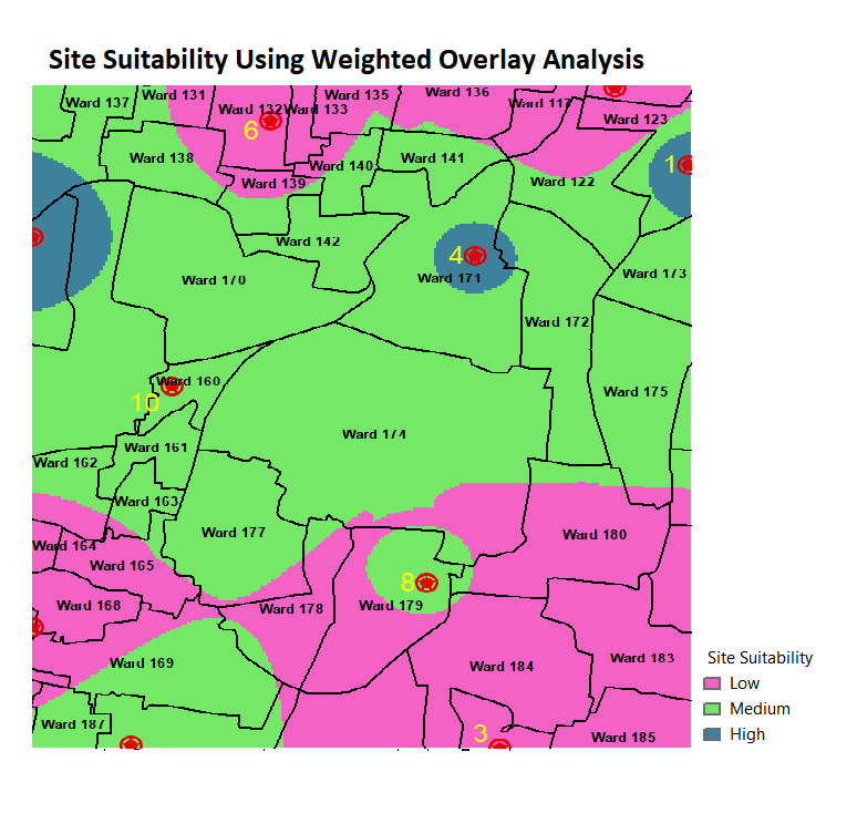
To find the exact location of shift the organization using Weighted overlay analysis based on the new suggested sites. the parameter which we consider to do the weighted overlay analysis such as Driving Distance of employees, Existing survival elements, Parking, infrastructure facilities of the location, Rental price.etc. 
This image shows the suitability of the new location for relocating.it is done by raster-based analysis, converting all the thematic layers into raster format and reclassifying them then assigned ranks/weightage based on the priority of the layers.
Conclusion
Here, I have created a sample dummy dataset and used some basic criteria to find the best site for relocating the IT Sector And, discussed the methodologies and tools which I used to find the best location. Kindly suggest your views in the comments section.
Do you find it interesting? you might also like these articles. Top 10 Best Tech Companies For Employees To Work In The USA In 2020 and Top 10 IT Staffing and Recruiting Agencies in the USA.
If you have a business idea in your mind and in search of a reliable web development company, you are in the right place. Hire the best web developers in the industry from Agira technologies.


