Table of Contents
In the Digital era, evolution in technologies motivates and inspires us to live a better quality of life. Digitization has made once the impossible visions come true. Internet of Things (IoT) and Geographical Information System(GIS) are one of those technologies we witness today.
Do you know the combination of these two technologies, IoT and GIS is eventually changing the world with it’s smart and integrated characteristics? IoT is offering boundless opportunities for consumers and businesses. The connectivity between the objects and able to collect a considerable amount of real-time data has made it efficient. On the other hand, GIS has a foundation of data collected through IoT devices and digital maps.
What is the Internet Of Things (IoT)?
Internet Of Things is a system that interconnects with a network of physical objects like sensors, computing devices, and software for transferring data over to other systems without any interference of human to human or human to computer interaction—for example, smart homes. Growth of the Telecommunication Industry offers us new connectivity offerings like 4G and even 5G services going to be connected soon.
The devices can connect with IoT range from ordinary household appliances to large industrial equipment. It is used for computing, and to minimize human intervention, with IoT, you automatically collect and share the data to align with your daily process with machinery or lifestyle.
Also Read
The Fusion of IoT and GIS
GIS is a technology used to keep tracks on the location of an object or user and store, manipulate the data for more digitized solutions.
GPS on smartphones, traffic conditions on maps, Uber rides, food delivery exact locations are some of the famous examples of GIS technology.
GIS and IoT are interrelated. Combining both gives a bigger picture with the range of objects, individual buildings and locations, and as well as large areas like smart cities, transit development, and disaster management.
When GIS and IOT work together, it offers benefits such as an increase in flow efficiency, cost efficiency, and, most importantly, can get real-time information from the sensors without the need for human intervention.
Architecture Of IoT and GIS

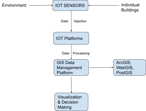
The above Flow chart is the system architecture of pairing IoT and GIS. IoT Sensors are conventional sensors used to collect data from the environment, traffic conditions, and locations like individual buildings, roads, and smart cities.
Data Injection is storing the gathered information into the IoT platforms like technologies that manage, provision and connect with the IoT World. The next step is Data Processing, where the data gathered from the IoT universe are used in GIS platforms. The collected data is for manipulating, storing, and analyzing by WebGIS, PostGIS, and ArcGIS applications.
Visualization and Decision making is to use all the data into the mapping layers. From the Identified data, we can visualize the environment and locations. This process is providing solutions to the digital world.
Now, let’s take a look at the real-world instances of how GIS and IoT are transforming for the enormous potential.
Smart Mobility Solutions
Transportation plays a crucial role in our lifestyle. Earlier it wasn’t easy, but we are traveling faster than time.
IoT and GIS give solutions like GPS enabled vehicles and information about the route we need to travel, and we can also get applications for finding hotels, rest stops, filling stations on the go.
By using IoT on Vehicles, we can connect to the LAN and connect with others. This tech takes control of the vehicle to avoid accidents. Also, it can report live data back to the relevant control room.
Smart Cities
An extensive range of data of whole cities can be collected by GIS and IoT sensors. From how many buildings, cars, and even lamp posts and reports of traffic, air, noise, and more. This can help the government track the pollution and improve the pollution levels.
For this process, we need to collect large amounts of data, and for this, IoT sensors can be installed on Cars, highways, roads, and buildings. In this way, we can track if any floods, forest fire, or disease occurrence that are likely to happen on a full range scale. Also, this collaboration can be used to make city planners create routes for cycling and biking. Even for water and drainage routes for better control.
Disaster Management
The government can utilize GIS and IoT data to simulate the impact of natural disasters such as fire and flooding. The government also takes preliminary decisions to determine the higher risks by analyzing the simulations of flooding. This will help the city planners to design better cities to eradicate these type disasters in advance thanks to the data collected via GIS and IoT.
Related to GIS
Conclusion
GIS and IoT, this fusion has some confronting challenges ahead of them. To name a few, they are Data Integration, Data Security, Data Storage, and hardware ruggedization.
Storage and integration of the data is the biggest challenge. The data are collected in different formats, such as images and videos, and more. Securing information is the most significant challenge as it includes the whole data of the real world of cities, which is now used for better business, improving decisions, and enhanced quality of life. We are sure the pairing of the two technologies will lead the ways for a better world.
Are you looking for more? Subscribe to weekly newsletters that can help your stay updated on Geographic Information Systems and IoT application developments.


